3rd Largest Local Municipality
Dr Beyers Naudé Local Municipality, spatially the third largest Local Municipality in the country, is well-positioned as a portal to the mystical Karoo, in a region renowned for its pristine natural environment, rich heritage, diverse peoples and cultures. The vast area (± 28,690 km² in extent) includes the towns of Graaff-Reinet, Willowmore, Aberdeen, Jansenville, Steytlerville, Nieu-Bethesda, Klipplaat and Rietbron; plus a number of smaller settlements and surrounding farms. It boasts several very popular tourist attractions, beautiful landscapes and a healthy climate. The town of Graaff-Reinet, 4th oldest in South-Africa and referred to as the “Gem of the Karoo”, is a hub of agri-tourism activity; it is the political and administrative seat of the Municipality and is the centre where the biggest concentration of the population lives and works. The second largest town is Willowmore, also with a strong and vibrant tourism and agricultural sector. Willowmore should be viewed as a strategically well-positioned centre for managing and co-ordinating service-delivery & public participation in the southernmost part of the Municipal area.
“A responsive, developmental and unifying Local Government providing quality services to its citizens in a safe, healthy and well-managed environment, with equal opportunities for all.”
Dr Beyers Naudé LM was established as a result of a merger between the former Municipalities of Camdeboo, Ikwezi and Baviaans – on 8 August 2016 – after the Local Government Elections held on 3 August 2016. Geographically the new Municipality makes up 49.19% of the Sarah Baartman District Municipality’s landmass, with a low population density of 2.8 persons per km2, which is much lower than the District average of 7.7 persons per km2. The area is characterised by large tracts of commercial farmlands that are sparsely populated. The most densely populated areas are found in and around the established main towns. There are vast distances between main centres; some of the smaller towns and settlements can only be reached by unsurfaced (gravel) roads, not all of which are being maintained on a regular basis. The most difficult areas to access are situated within the Baviaanskloof.
The towns in the region have their own unique dynamics and attractions that draw visitors from far and wide, many of whom have made this their home. Well-known personalities that have carved a niche in our country’s history and are closely associated with the Dr Beyers Naudé LM, include the likes of Robert Mangaliso Sobukwe, Dr Anton Rupert & Dr Beyers Naudé, Rev. Andrew Murray, Prof James Kitching, Athol Fugard, Anna Neethling Pohl, DF Malan, Helen Martins, Andries Pretorius…
Key features of the area include :
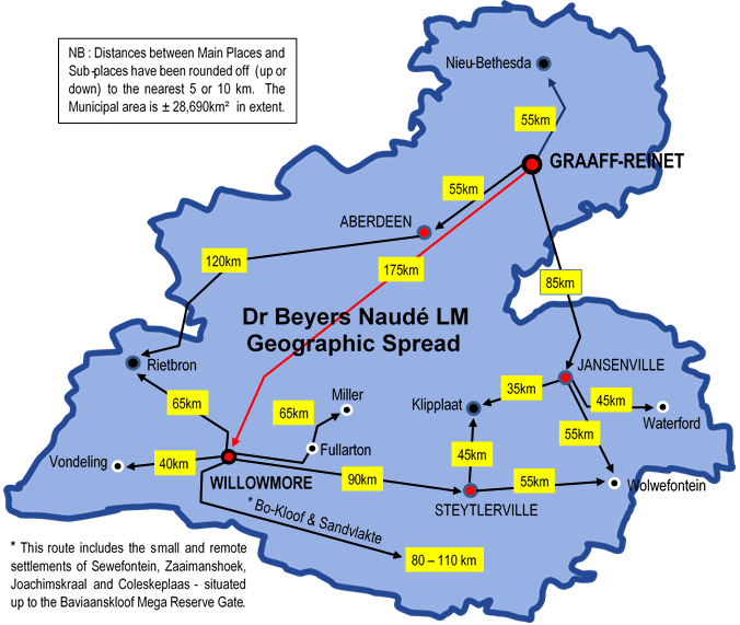
Vast Geographic Spread
Being situated in an arid area within the Sarah Baartman District, Dr Beyers Naudé LM faces many challenges, the biggest of which is water. Aberdeen and Nieu-Bethesda are in the fortunate position of having perennial springs that supply adequate and good quality water, which is used for both domestic consumption and irrigation. Graaff-Reinet gets its supply from the Nqweba Dam; when dry, the town is dependent on borehole water ~ an unreliable source as the water table drops drastically when the rain stays away… Other towns, such as Willowmore and Steytlerville, experience critical shortages at times and water quality is a problem in other areas, such as Jansenville. The lack of a sustainable and permanent water supply is probably the most inhibiting factor in the area’s economic development, as it restricts both agricultural and industrial activities.
Of particular concern is how the vast geographic spread of the new Municipal area has impacted on the delimitation of Ward boundaries, placing towns and settlements that are not only huge distances apart, but have wholly different situations and needs, in the same Ward; making Community-based planning and service delivery very challenging for the new Municipality and its Ward Councillors. Some towns and settlements in the split Wards are also spatially divided by geographic features such as mountains, rivers and farms, and are not connected to each other by direct routes; some are more than 50 kilometres apart. Even the Camdeboo National Park appears to now straddle two Wards, namely 2 and 7 and the Camdeboo National Park / Mountain Zebra National Park Protected Environment, currently 275,082 hectares in extent, is a good example of a cross-boundary partnership. The Protected Environment straddles two Local and two District Municipal areas.
Integrated Development Planning
All planned development within the Municipality must be structured in accordance with the 5 Key Performance Areas also referenced in Section 1.4 of Chapter 1 of the IDP. Each KPA consists of one or more Development Priorities, identified during the public participation processes, as well as consultations with internal Roleplayers. These Development Priorities are to be addressed through either the Municipality’s Capital Budget Programme, or form part of its day-to-day operational activities.
| KPA 1 | Organizational Transformation & Institutional Development (including Institutional Plan, HR Strategies & Policies, OPMS) |
| KPA 2 | Service Delivery & Infrastructure Planning including FBS, Human Settlement & Spatial Planning, SDF, LUMS, Biodiversity, Disaster Management) |
| KPA 3 | Local Economic Development (including LED Strategy & Action Plans, SLED) |
| KPA 4 | Financial Viability (including MTREF Budget, Financial Plan, Audit Reports, Systems & Policies) |
| KPA 5 | Good Governance & Public Participation (including Communication, IGR, Social Cohesion, Special Programmes) |
koos
During October 2016 and into November 2016, the IDP practitioners in the employ of the Municipality, embarked on a series of Community-Based Planning workshops, which was the precursor to the development of a new 5-year Integrated Development Plan (IDP) for the new Council. All 14 Wards were covered and much information was obtained about the Wards by way of a thorough SWOT Analysis conducted during each focus-group workshop, which forms part of the Municipality’s public participation programme. Critical issues were identified, and from those, the Ward Development Priorities were unpacked. Vision and Mission Statements were developed for every Ward; these in turn informed the IDP’s institutional Vision and Mission, Development Priorities, etc. – they are dealt with in more detail under Chapter 4.
The IDP’s High Level Development Priorities (mainly Capital Programmes) can be categorized as follows, each with a cluster of Focus Areas :
“Throughout the IDP, the Municipality has demonstrated the extent to which it embraces and applies the Back-to-Basics principles. This is further reflected on in the IDP’s Project Register.”
ANNUAL REVIEW
Dr Beyers Naudé Local Municipality’s 2017 – 2022 IDP is subjected to a rigorous annual review (a legislated requirement), during which progress or non-progress in addressing the 14 Wards’ Development Priorities is also interrogated and general content of the IDP is updated in line with recent analysis, guidelines or directives. Public Participation and proper consultation are key to the process and various structures – such as Ward Committees, IDP Steering Committee and IDP Representative Forum – are utilized to enhance the process and ensure that a credible IDP is produced for tabling to Council and assessment by COGTA.
IMPLEMENTATION
The implementation of this IDP will be one of the Municipality’s greatest challenges, faced as it is with severe financial constraints, inadequate capacity and insufficient resources – mainly as a result of the amalgamation. Dr Beyers Naudé LM inherited huge outstanding debt, assets that were in a poor and unusable state, and many that remain unaccounted for. The Municipality will require a great deal of support and assistance to achieve its strategic objectives, which aim to create a better situation and a good quality of life for its Communities, as encapsulated in the IDP’s Vision Statement.
Financial and non-financial Key Performance Indicators (KPIs) and quarterly targets for annual capital projects and operational programmes are contained in the IDP by way of the SDBIP. Monthly Progress- and quarterly Performance Reports enable Management and Council to monitor and evaluate the implementation of capital projects and achievement of service delivery targets.
The Dr Beyers Naudé Municipality’s Final 2021/22 IDP was approved by Council on 31/05/2021 (Res. SCOUN-040.1/21) and ratified on 21/06/2021 along with the approval of our 2021/22 MTREF Budget (Res.SCOUN-076.1/21). The Municipality’s 2021/22 Capital Budget proposes to fund projects to the value of R86.9 million, mainly from grant funding.
For more on the IDP and Community-based planning, please click on the following link :
Dr Beyers Naudè Local Municipality, the latest IDP documentation.